Another Day, Another Island: Touring the Bahamian islands via GA is the way to go
Three minutes after pushing the Cessna Caravan’s power lever forward at Fort Lauderdale Executive Airport, AOPA President Craig Fuller guides the lumbering airplane across the Florida coast and out over the Atlantic Ocean.
Fuller, along with five AOPA staff members and Greg Rolle, aviation tourism director for the Bahamas government, are on the way to the offshore islands that have been a top international destination for U.S. general aviation pilots for decades. Our first stop, Stella Maris Airport (MYLS) on Long Island in the southern portion of the archipelago, is 305 nm away. This will be Fuller’s first visit to the Bahamas via GA.
Rolle is in the Caravan’s right seat, and the irrepressible former Olympic 400-meter hurdler keeps up a steady, good-natured banter that touches on the islands’ history, their character, their future, and the endless opportunities for escape and adventure they offer GA pilots and passengers.
“All we have is sun, sea, and sand,” said Rolle. “Our economy depends on tourism, and we take the subject very seriously and approach it in a long-term way.”
Rolle, an instrument and multiengine pilot, learned to fly so he could better serve and understand the aviation community, its specialized concerns, and potential for increasing tourism. GA visitors are especially important to the pristine “out islands,” far beyond the capital Nassau, because few cruise ships stop at such places.
“Every island and its people have their own unique character,” Rolle said. “If you don’t like one island, go to another and see if it’s better. You can go to a new island every day for two years in the Bahamas and still not visit them all.”
 During 15 years on the job, Rolle has helped increase the number of airports in the Bahamas where international pilots can clear customs to 23, upgraded airport facilities, and established nine U.S. “gateway” FBOs that assist GA pilots bound for the islands.
The Caravan is level at 9,500 feet on an international VFR flight plan, cruising at 162 KTAS and bucking a 30-knot headwind. But just 20 minutes into the flight, we pass over Bimini, the closest island to the United States in a chain of more than 700.
During the first two hours of a planned three-hour flight, the Caravan is in continuous radio contact with air traffic controllers in Miami and Nassau, on ATC radar screens, and often within gliding distance of land. After Bimini, the Caravan crosses the islands of Andros, New Providence, the Exumas, Eleuthera, and Cat. All the islands have airports, and some of them have multiple airports.
The exotic islands are known for world-class beaches, fishing, scuba diving, sailing, and other ocean sports. They’re within easy reach of most single-engine, piston GA aircraft—although many of the airplanes based here are twins, with Piper Aztecs and Navajos and Beech Barons the most plentiful. The islands have largely recovered from the devastation of Hurricane Irene, a Category 3 storm that tore across the low-lying chain on August 25, 2011 (see “Rally GA: Flight for Survival,” November 2011 AOPA Pilot). Rolle said tourism dollars are especially welcome because they accelerate reconstruction.
Rolle credits flying with giving him a new appreciation for his own country. “I was born in Nassau and grew up in Nassau and didn’t really travel to the other islands,” said Rolle, who retains a lanky, athletic build long after his track career peaked at the 1984 Olympics in Los Angeles. “It wasn’t until I started flying that I visited all the islands. It’s made me love my own country and the Bahamian people so much more. I didn’t expect that could happen as a result of learning to fly.”
Rolle attends U.S. aviation events such as AOPA Summit and EAA AirVenture each year, and he brings a contingent of Bahamian officials who work in areas such as customs and law enforcement. By showing them the size and variety of the GA industry, he convinces influential Bahamians that aviation must remain central to their tourism strategy—and that they should make it as easy as possible for U.S. pilots and their guests to visit.
The paperwork involved in flying between the United States and the Bahamas is less burdensome for U.S. pilots than most international destinations. Pilots and passengers fill out one form to enter and exit the Bahamas. They and their passengers also must bring current passports, and pay a $25 departure tax. The United States requires that pilots file electronic eAPIS customs screening forms for both departures and returns. But even that sometimes-intimidating process has become less cumbersome, and iPad and iPhone users can download applications that make eAPIS clearer to navigate.
Fifty minutes into the Caravan’s eastbound flight, Fuller checks in with Nassau Approach, and the controller’s unmistakable Caribbean accent (“Turn soud-east now”) is a reminder of the fact that we’re in Bahamian airspace.
It’s midmorning, and eight more GA airplanes are on the way to Stella Maris from Fort Lauderdale. Jack McCormick, head of Baja Bush Pilots, is leading 16 people on a circuitous tour of the Caribbean and Central America. The group’s first stop outside the United States happens to be the same as ours.
“Caravan Three-Nine-Four-Golf-Alpha, there are lots of airplanes going to Stella Maris today,” the controller says. “When does the party start over there?”
“As soon as we land,” Rolle quips.
Looking down
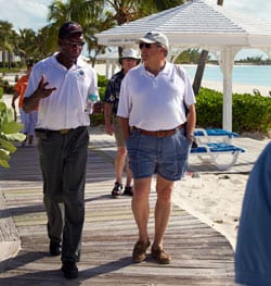
Greg Rolle, aviation tourism director for the Bahamas, talks with AOPA President Craig Fuller.
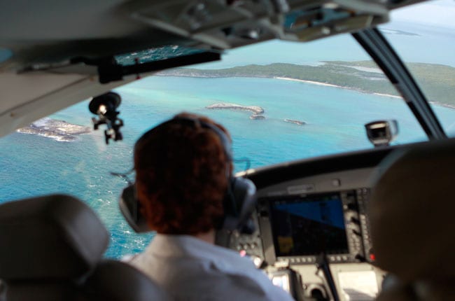
Miles of shallow water after Bimini reflect dazzling blues and greens, and steady southeast trade winds of 15 knots or so at sea level give a rough texture to the ocean surface. The water is so clear that the contours of the white sand and rock and coral reefs underneath are easily identifiable, and constantly changing.
The sky has been mostly clear except for puffy cumulus clouds over each island during the first half of the trip. But the clouds thicken, and we climb to 11,500 feet to top a broad stratus layer.
About 75 nm from our destination, the clouds break up, and we start our descent in clear, smooth air with a few rainshowers visible to our north.
The ocean is deep blue and thousands of feet deep, but it shallows and becomes an iridescent turquoise and sky blue as we approach the low sandstone cliffs at the northwest edge of Long Island. Stella Maris is visible 20 nm away, and we’re aligned for a straight-in approach to Runway 13. But we take a quick aerial tour of the island by circling at 2,000 feet in a series of wide right turns.
Stella Maris Resort is situated on the rocky and dramatic windward side of the island. Wind-driven swells crash into the craggy shoreline in endless succession. On the protected lee side of the island, vast sandbars provide miles of shallow water ideal for bonefish, a prized quarry for fly saltwater fishermen around the world. And a series of protected harbors provide ideal anchorages for sailboats, yachts, and fishing boats.
The unicom frequency, 122.8 MHz, gives a hint at the aerial activity throughout the island chain as a de Havilland Dash 8 turns final at Deadman’s Cay on Long Island, a Bonanza arrives at Staniel Cay in the Exumas, and a Piper Aztec leaves New Bight on Cat Island—all of which share the same radio frequency as Stella Maris. The higher you fly, the more distant transmissions you hear.
We turn base over the talcum sand beach at Cape Santa Maria Resort, named for Christopher Columbus’s flagship, which is said to have anchored here in October 1492 a few weeks after making its first landfall in the New World.
We touch down on the 4,000-foot runway and pull onto the first of two ramps. The area was hard hit by Hurricane Irene, which brought 155-mph winds and destroyed two airplanes on the ground. But there’s no obvious sign the place was damaged (although two roofs blew off airport buildings, and the storm surge sent saltwater onto airport property).We clear Bahamian customs and soon we’re on our way to the hotel in a taxi.
The temperature at Frederick Municipal Airport in Maryland was well below freezing when we left. Here it’s 78 degrees Fahrenheit; a sea breeze blows steadily across the beach; and a fiery red sunset is blazing in the west. The NFL playoffs are on TV, and the games that will determine the teams that play in the Super Bowl draw huge interest around the world. But the images from frigid New England seem as though they’re being beamed in from another planet. This place is a scant few hundred miles from the United States, but it feels a world apart.
Wild West
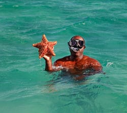
Snorkeling in the Bahamas is like swimming in a saltwater aquarium; Bahamian guide Andy Gibson displays a starfish.
Flying VFR within the Bahamas doesn’t require filing flight plans, and most GA trips take place in daytime and good weather. A morning flight to Staniel Cay (the second word is pronounced key) at the north end of the Exumas is a short, 30-minute hop via Caravan. The 3,030-foot, north/south asphalt strip is known for challenging crosswinds, but the afternoon trades haven’t kicked up yet, and the windsock is nearly slack at the time of our arrival.
We empty the Caravan of as much gear and as many passengers as possible because it is returning to Florida right away. Bahamas Habitat has a large shipment of construction materials for the Zion Children’s Home on the island of Eleuthera. Most GA volunteers flying to the Bahamas are only able to carry light loads, but the Caravan’s cargo pod and generous payload allow it to transport a great deal more. AOPA pilot Luz Beattie flies the Caravan to Orlando Executive Airport and back to the islands carrying more than 1,000 pounds of donated materials. She lands at Staniel Cay just before sunset (and this time the crosswind is gusting 20 knots).
The Staniel Cay Yacht Club is about one mile from the airport, and as soon as we stow our gear, we’re on our way to the dock to find a boat that will take us snorkeling in the Exumas, an incomparable network of hundreds of white-sand islands and cays separated by crystal-clear water.
Jumping into the ocean at a vast marine sanctuary, a dazzling variety of fish surround our boat. Yellowtail snapper, red snapper, bass, parrotfish, triggerfish, angelfish, barracuda, needlefish, and a dozen more kinds I don’t recognize are close enough to touch.
We also dive at the wreckage of a Cessna 210 that came to rest inverted in about 20 feet of water. The airplane is largely intact, although most of the tail section and the right-side door are gone. Coral has taken root along the fuselage, and a large brown moray eel is in residence in the cabin. Our tour guide says the Cessna had been commandeered by drug runners when it crashed on New Year’s Day more than 10 years ago. The pilot reputedly swam to one of the many nearby cays and evaded capture.
The wreckage harkens back to the region’s lawless days 20 years ago when South American drug cartels literally invaded Norman’s Cay and other islands with paramilitary forces and vast stockpiles of cash. The cartels smuggled huge quantities of drugs into the United States from remote airfields using airplanes ranging from the ill-fated 210 to large, four-engine transports.
The Bahamas’ geography provided an ideal refuge for smugglers: Hundreds of remote, sparsely populated islands near the U.S. mainland with a small police force and many poor inhabitants. It took a sustained effort from Bahamian officials as well as a massive buildup of U.S. law enforcement, increased radar surveillance, and aerial and marine intercepts to drive the smugglers from the region.
“The 1980s and 1990s were like the Wild West out here,” said a pilot who flew regularly throughout the Bahamas in that era. “It was a dangerous time, but thankfully, those days are over.”
Auction winner
The small ramp at New Bight Airport on Cat Island was overflowing with airplanes when the AOPA Caravan arrived—and they looked familiar. The Baja group had arrived first, and we caught up with them at Fernandez Bay Village Resort—and stumbled upon an extremely unlikely coincidence. One of the pilots on the Central America trek—J. Bruce Camino, an architect who bases his Piper Comanche at Fullerton Airport in Orange County, California—was the winning bidder at AOPA Summit’s Night for Flight benefit auction for an air-to-air photo shoot with the AOPA staff. We had been in touch with him by phone and email, and had made plans to travel to California in February to fly with him.
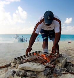
A “shore lunch” of freshly caught conch and lobster in the making.
But it turned out Camino was flying with the Baja group, and a fellow tour pilot, Eric Ortiz, volunteered to fly his Bonanza G36 as a photo platform to do the photo shoot over Cat Island. AOPA Photographer Chris Rose joined Ortiz in his Bonanza, I flew with Camino, and we lucked out with absolutely ideal conditions for photography during a late-afternoon flight over the island’s incomparable coastline.
“I had high expectations when I bid on the AOPA photo shoot, and was confident that we’d manage to get a few high-quality pictures of my airplane,” Camino said. “But the fact that we were able to meet in one of the world’s most incredible and scenic locations was almost beyond belief. It was a better experience than I could have possibly hoped for.”
Another airplane that arrived at Cat Island was a Light Sport aircraft, a Breezer that had come as part of a group of LSAs following the Sport Aviation gathering in Sebring, Florida. Mike Zidziunas has flown his Rotax-powered aircraft to the Bahamas on eight round-trips in the last two years, and many more GA pilots have followed his lead. “They can’t help notice that if we can make this trip safely in LSAs, surely they can do it in their 182s or 206s,” Zidziunas said. “And after they’ve done it once, they’re hooked.”
Crooked Island
The approach to the oceanfront Pittstown Point airfield on Crooked Island and its 3,500-foot, east/west runway is spectacular. Watch for the lighthouse on left base, turn final over the reef, and see your airplane’s shadow cross the shallow water to the runway. Jagged coral reefs drop off to tremendous depths of many thousands of feet close to shore, and game fish patrol only a few miles offshore. Prized bonefish cover perfectly pure sand banks, and anglers come from all over the world to pursue them.
“Places like this are extremely difficult to get to any other way,” said Ferrell J. “Frenchy” Lasseigne, a New Orleans business owner who flies a Piper PA–46T Jetprop to a vacation home at Crooked Island. “You can get here by airline, but it usually takes at least two days and involves spending at least one night in Nassau each way. And it’s just too far for most people to get here by boat.”
The reward is an absolutely dazzling setting at a Hemingway-esque location that is far off the beaten path. Lobster are huge and plentiful; conch are abundant; and the fishing and diving rival the world’s best locations. There aren’t any swank resorts or four-star hotels, but the people who come here say they prefer it that way. “You’ve got to want to be here to get here,” Lasseigne said.
Going home
The rapid-fire ATC instructions on the Miami Center radio frequencies are a bit jarring as we approach the U.S. coastline on the return to Fort Lauderdale Executive Airport and Banyan Aviation. The Caravan’s radio had been largely silent, and the push-to-talk switch had received little use in the islands.
We clear U.S. Customs in 30 minutes at Fort Lauderdale. The only things any of us bring home are sea shells, gifts for family members, and winter tans. XM Weather confirms our return to winter reality on the trek north as pink and blue shades of freezing precipitation appear west of our route in Virginia and West Virginia.
Fuller, a GA pilot for more than 40 years, says the Bahamas trip was an eye-opener. “I can’t understand why I haven’t flown there before,” he said. “I’ve flown up and down the East Coast countless times, and I’ve sailed in the Bahamas. But I’d never realized how accessible the islands are via GA—and I look forward to flying back.”
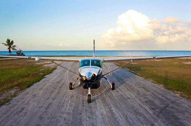
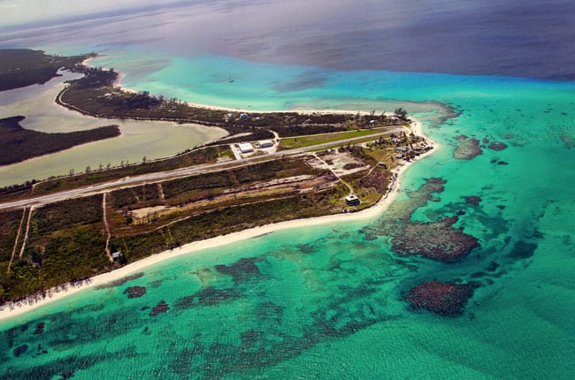
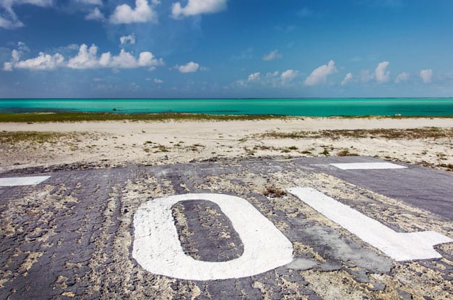
The threshold to Runway 10 at Pittstown Point on Crooked Island is beachfront property. The steep dropoff to deep water is ideal for scuba diving and fishing, and the amount and variety of sea life is dazzling. Crooked Island is one of the most distant from the United States in the Bahamas chain, but it’s well within reach of most GA piston aircraft.
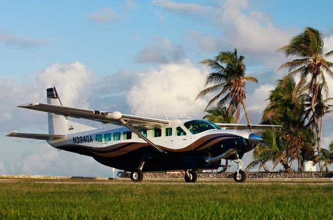
It’s hard to imagine a better airplane for the Bahamas than the Cessna Caravan. The heavy hauler operated easily out of unimproved airstrips, and its cargo pod and long range allowed it to bring bulky items and donated construction material to the more distant “out islands.”
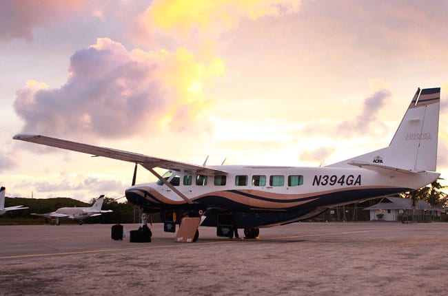
Stella Maris Airport was hard hit by Hurricane Irene in 2011, but the storm damage has been repaired and the facility is fully open for business; U.S. pilots can clear customs there, and fuel is available for both piston and turbine aircraft.
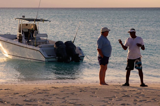
A pristine beach on Crooked Island is a fascinating place to explore.
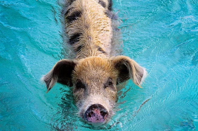
A herd of pigs in the Exumas is known for swimming out in search of food to visiting boaters.
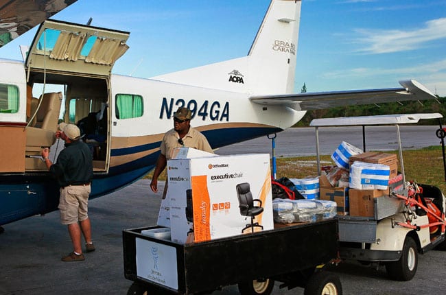
The Cessna Caravan transports donated goods and building materials to a damaged children’s home.
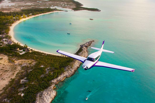
Comanche owner J. Bruce Camino painted his airplane in the colors of the University of Washington Huskies, his alma mater. We crossed paths at Fernandez Bay Village Resort on Cat Island while Camino and a group of fellow travelers were circumnavigating the Caribbean via the Bahamas, Cayman Islands, and Central America.
by Dave Hirschman
AOPA Pilot Magazine
Photography by Chris Rose
Original article: http://www.aopa.org/members/files/pilot/2012/march/f_bahamas.html


